This is a long read, triggered by a recent article in The Economist lauding Hyderabad’s vertical growth-enabling policy.
It is an opportunity to think more broadly about the drivers behind Hyderabad’s spectacular urban growth over the last three decades, one with few precedents in India. Also, to avoid drawing the wrong lessons from the city’s success in economic growth and real estate development, this post will provide some qualifications. It will point to the role of the government, the political economy and the role of large developers, and the consequences of deficient urban planning. Finally, it will offer some comparison between the Hyderabad model and those of Gurgaon and Shenzhen.
The Economist article lauds Hyderabad’s vertical growth and the enabling policy of the government.
Hyderabad, unique among India’s cities, abolished fsi in 2006. And then, miraculously, life went on. NIMBYs foretell all sorts of doom the moment anyone talks about building anything. They warn of Gothamesque ghettos with gridlocked streets, dry taps and overflowing sewers. Nonsense. Today tall residential blocks line the highways in Hyderabad’s western suburbs and traffic still flows faster than in most major Indian cities. Dozens more towers, including the Trump ones, are sprouting in a neighbourhood called Kokapet that was not long ago full of custard-apple orchards and is now a forest of construction cranes.
There are two reasons Hyderabad has not descended into dystopia. One is its 160 km-long orbital motorway, the first bit of which opened in 2008 and is now an arterial road in the new skyscraper belt. The other is that abolishing the arbitrary cap on FSI did not mean the abandonment of all rules. Regulations covering minimum street widths and required setbacks still apply. Aviation authorities impose restrictions around air-traffic funnels. The effect is that developers can build high only if they have a large enough plot next to a wide enough street somewhere far enough from an airport. Markets decide the rest. The cost of construction rises with height, so a builder’s decision about how much to pay for land and how tall to go rests on whether potential buyers of flats will cough up enough to make the project profitable. That has prevented a housing bubble.
For a start, Hyderabad’s spectacular urbanised growth over the last three decades owes primarily to government actions. Four, in particular, stand out.
1. The spurt of IT services industries locating to Hyderabad provided the economic anchor to sustain the spectacular property development that followed. Its emergence owes all to government policies. From having nothing apart from a small software cluster at Mythrivanam, the spectacular boom in the IT industry was catalysed by the conscious efforts of the then government of Andhra Pradesh in the mid to late nineties. It established the 158-acre HITEC City at Madhapur through a PPP between APIIC and L&T, with Cyber Towers being the iconic building. The then Chief Minister, Mr Chandrababu Naidu, toured the US and Singapore extensively, wooing software firms, and his efforts culminated in Bill Gates's visit in 2001 and the announcement of Microsoft’s largest R&D centre outside Redmond. It was followed by GE and ICICI and a flood thereafter and continues to this date, expanding to all kinds of sectors and innovations. The Cyberabad brand took off.
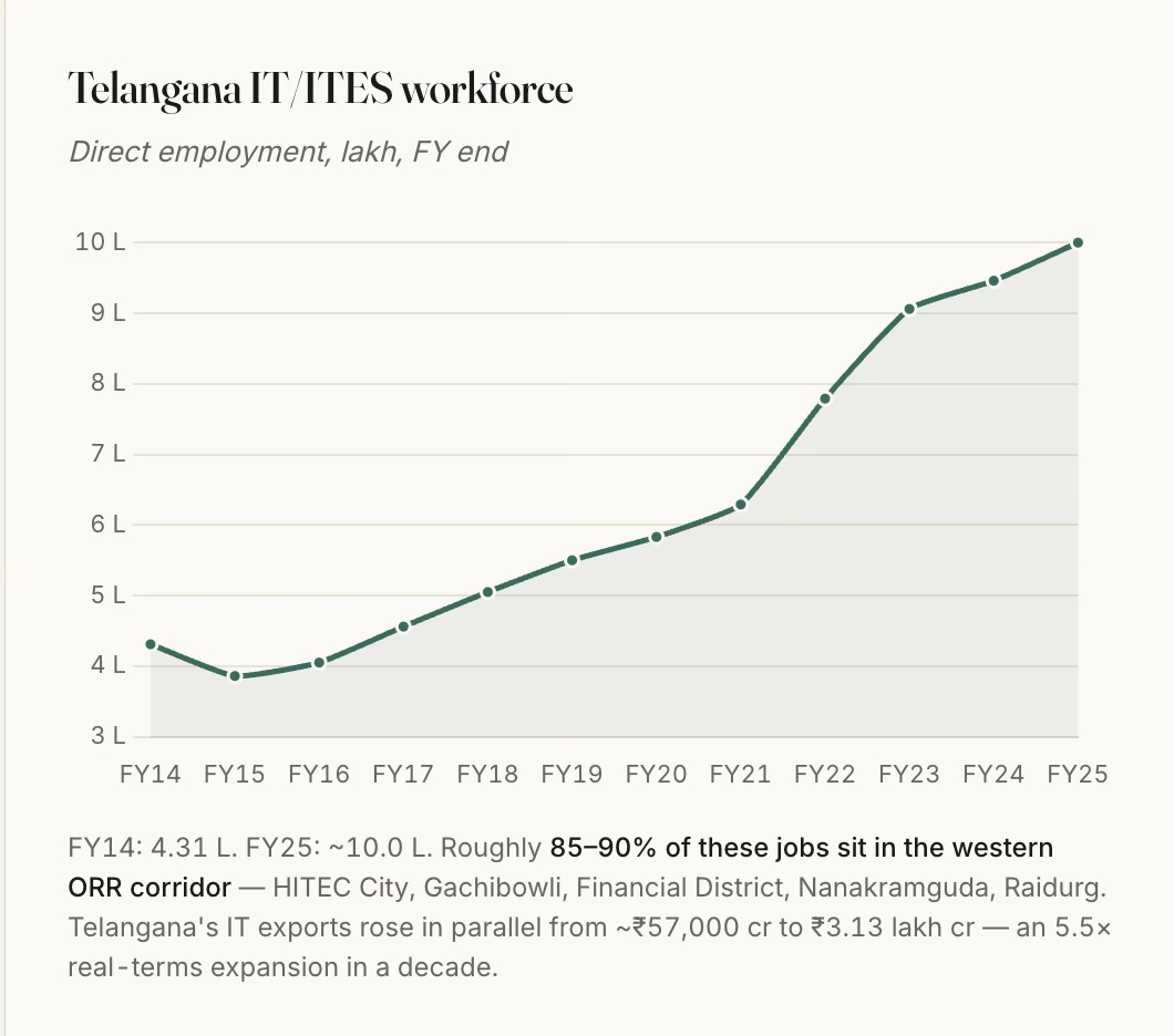
Starting with a few hundred in the early nineties, Telangana state’s IT employment has moved from 0.4 million in FY14 to about a million in FY25, and 85–90% of that sits in the western Hyderabad corridor.
2. The state’s IT services push was supported by the Andhra Pradesh Infrastructure Investment Corporation (APIIC)’s model of acquiring land, developing trunk infrastructure (transport and utilities), and leasing/selling with clear titles through a single window at concessional rates to incoming firms. This too, like with the ORR, had its set of controversies and scandals.
Apart from the L&T HITEC City, APIIC developed the initial 100-acre Financial District at Nanakramguda, and several others. HMDA has been the price-discovery mechanism for the entire premium belt through its periodic auctions that have unlocked vast extents of government lands. The high premium commanded by these auctions is also because the state layout provides serviced plots with clear title. This is closer to a Chinese SEZ-style state land-lease model than to Gurgaon's private-land-assembly model.
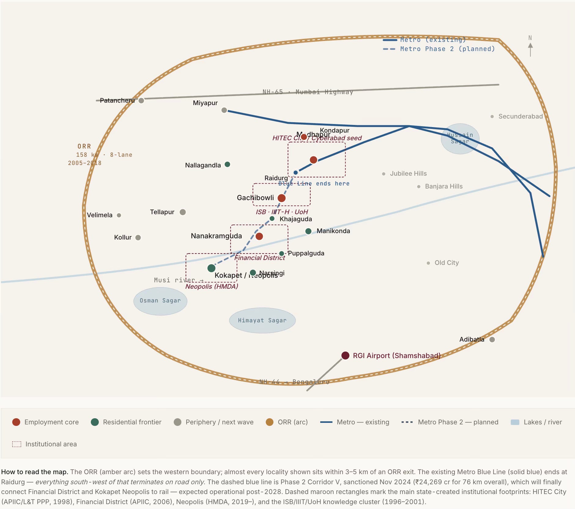
3. The Outer Ring Road (ORR) has been transformational to the urban growth in the western part of the city. Notwithstanding all the controversies on the alignment finalisation, land acquisition, contracts, and tolling, the Hyderabad ORR should count as a totemic example of high growth-catalysing infrastructure investment in India’s history. It unlocked value by enabling the vast hinterland of barren and rocky lands to become productive centres. It was a truly visionary project when conceived in the early 2000s and even when its execution started in 2005.
The ORR enabled orbital and radial access to the city, thereby resetting the commute dynamics and unlocking vast barren lands, reducing times by multiples. It is no surprise that every land price in the corridor is capitalised against ORR access time. HMDA’s designation of a 1-km high-density buffer on either side of the ORR effectively unlocked about 316 sq km of premium-development-eligible land, the value created from which dwarfs the ₹6,700 cr cost of the road itself.
The ORR did the work of several economic growth crowding-in instruments, and produced the pattern of intense capitalisation of access to it, and (on the flip-side) the neglect of everything it does not touch.
4. The last enabler, the subject of The Economist article, is the deregulated development control regulations, specifically the unlimited FAR adjoining wide roads brought in by the GO Ms No 86 of 2006. In fact, even among the DCR, the GO’s success was only in its deregulation of the FAR. The high FAR manifests in the most salient aspect of Hyderabad’s real estate growth, the skyline of massive high-rises.
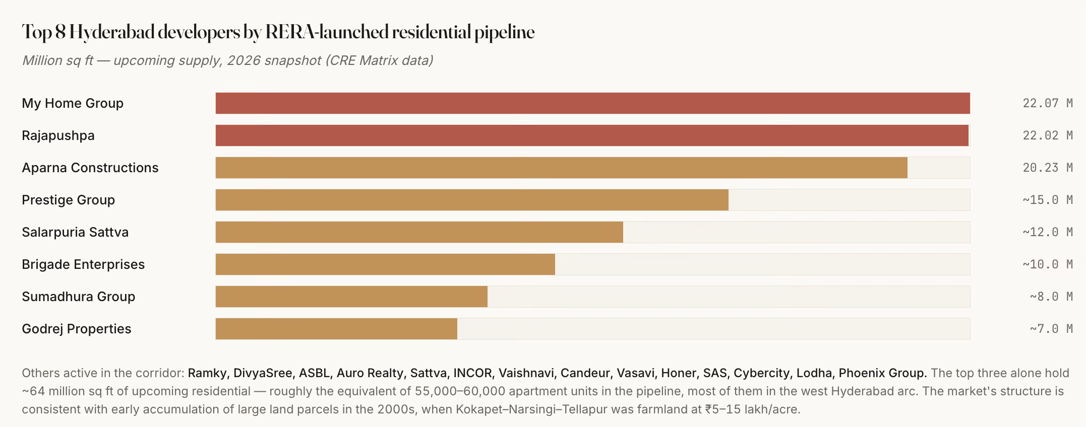
Even with all the above, it also critically required the enterprise, vision, and risk appetite of a handful of local real estate developers (My Home, Rajapushpa, Aparna, etc.) who hoarded large land banks in anticipation of the developments since the late nineties and early 2000s in the run-up to the boom. Only large real estate developers could afford to take the risks that lock up huge upfront capital and endure the vagaries of business cycles.
However, it has managed to escape the market concentration that characterises markets like Gurgaon. The nature, scale and pace of development have also ensured that while a dozen developers account for the bulk of Grade-A supply, and the top three alone control about 64 million sq ft of upcoming pipeline, there is a long tail of over 30 mid-tier local names.
Such entrepreneurship could also flourish only in a political economy and social milieu which condoned the often questionable overlapping of public and private interest, and deep-rooted corruption. Governments changed, but the underlying model and ongoing work continued unhindered. It is a very good example of Mancur Olson’s stationary bandit at work.
The combination of the 158-km Outer Ring Road, an unlimited-FSI building regime, a hospitable IT policy, and a handful of developers with 2000s-era land banks has added roughly a mid-sized city's worth of office, housing and vehicles to a 200-square-kilometre arc of west Hyderabad in about a decade-and-a-half. The public sector supplied the foundation. The private sector built on it. What emerged are pockets of car-dependent, single-use, higher-income, gated communities, with limited mass transit or affordable housing.
This brings us to the issue of urban planning.
Here, apart from the single instrument of unlimited FAR in the development control regulations, it is notable that the state fell short on the critical aspects of urban planning - master-planned mixed-use, walkable street grids, timely metro and mass transit access, transit-oriented density transfer, affordable housing, and vibrant public spaces and community life (apart from those in the gated communities). Even the unlimited FAR has its set of problems.
However, it can also be argued that more than state failure, these outcomes were the result of private incentives and the political economy overwhelming urban planning imperatives. The reality of developers with large land banks near the ORR and their close relationships with both politicians and bureaucrats trumped all other factors.
In any case, they have had several undesirable long-term consequences. Here are a few.
1. Residential real estate development has almost completely taken the form of high-rise gated communities and villas, all serving the upper middle-class and above. Affordability has been the casualty.
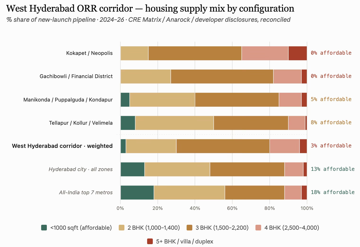
The sub-1000 sqft supply is a mere 2–4% of the west corridor’s pipeline, versus 13% for Hyderabad city and 18% at the all-India top-7-city level. Apart from public housing under various government schemes, it will be a big surprise if there is even one development of housing in the 600 sqft range and below, catering to the lower-income class. The corridor’s default product is a 1,500–2,200 sqft 3 BHK, forming half of everything built, and easily catering to the upper-income class.
This is a resounding nod to the reality that even in the most deregulated contexts and rapidly growing economic regions, affordable housing and lower-income housing will remain heavily under-supplied. It must be acknowledged as an area of market failure, requiring policy action.
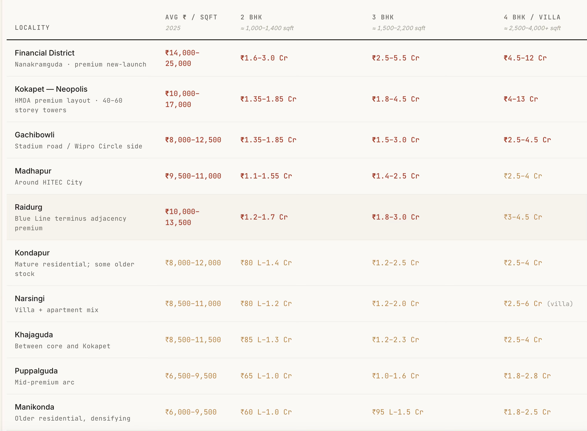
A ₹10 lakh household income supports roughly a ₹65–80 lakh home, which puts everything from Kokapet, Financial District, Gachibowli, Madhapur, and Raidurg out of reach for a typical mid-career IT professional. Even a ₹25–30 lakh household income (senior IT / GCC AVP) is stretched at ₹2 Cr pricing in Financial District. What this means is that the corridor is now selling primarily to senior tech and finance executives, NRI, and dual-earner-tech/finance households. Junior and mid-level tech workers are being pushed to Tellapur/Kollur/Miyapur. Even in these peripheral areas, sub-1000 sqft housing reaches only about 8%.
2. The revenue bias of the state government may have compounded the problems. The massive premiums commanded in the land auctions, coupled with the restrictive DCR (on setbacks and open space requirements), have distorted the real estate market and skewed it significantly upwards. For illustration, at ₹150 cr/acre for Neopolis land, the input land cost alone works out to ₹8,000–10,000 per saleable sqft (assuming 2.5–3.5 FSI usable given the large setback and open-space rules). Add construction (₹3,500–5,000/sqft for a premium tower), financing costs (typically 12–18% of project cost), developer margin (20–30%), and GST and other statutory levies/fees, and the total cost comes to ₹13,500–17,000/sqft. This land economics forces ₹4 Cr and above units. In contrast, in Velimela, where land is still ₹5–10 lakh/acre (not for long, one would imagine), 2 BHKs can come at ₹40 lakh.
In fact, it can be safely said that the entire land-use regime consisting of the ₹150 cr/acre Neopolis land price, the setback rules that make sense only for large plates, the developer economics that require more than ₹80 lakh units to sustain the ORR-belt cost stack, has displaced sub-1000 sqft out of the ORR corridor. The real affordable-format supply in Hyderabad now exists outside the ORR corridor’s western arc, in Miyapur, Bachupally, Nizampet, Kompally (north-west), Kukatpally (central), Uppal, Nagole, LB Nagar, Ghatkesar (east), and Rajendranagar, Shamshabad, Adibatla (south). These are outside the ORR corridor’s western arc. Anarock’s Q3 2025 Hyderabad realty breakdown indicates that 87% of the new supply added was in the premium, luxury, and ultra-luxury segments, priced upward of ₹80 lakh, a figure which rises to more than 95% in the ORR corridor. These are figures that point to a serious housing crisis.
3. This has been despite the HMDA having a 5% of developable area mandate for each of the Economically Weaker Section (EWS) and Lower Income Group (LIG). Builders have the flexibility to construct it on alternative land within a 5 km radius. However, there is not even a single instance of any developer having built physical units using this option. Instead, they have preferred to use the cash-out loophole of paying a shelter fee, which was carved by amending the Special Development Regulations for the ORR Growth Corridor. It allows developers to pay a capitalisation fee equivalent to 1.5 times the basic land value to HMDA. The low basic land value means this becomes a cheap option, one immediately capitalised into the cost of construction.
This must count as one of the biggest missed opportunities of Hyderabad’s ORR-based growth, and adds to the list of planning and policy failures. More importantly, the amendments to the EWS/LIG mandate underline the dominance of real estate developer interests.
4. Also, given the lack of any public transport connectivity linking them, these gated communities are car communities. The very large enclosed boundaries of these communities mean that they are not walkable localities, thereby further isolating the communities and increasing the reliance on cars.
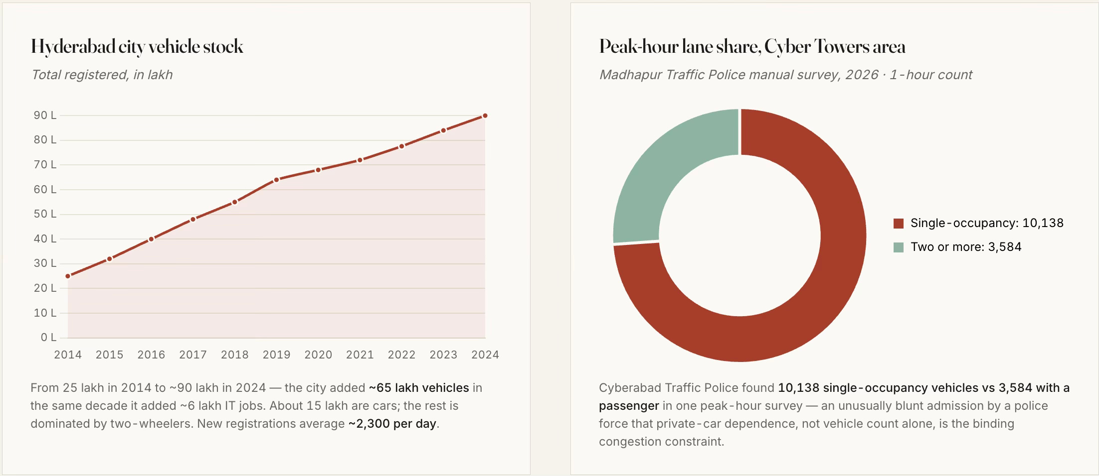
The Phase 1 Blue Line of the metro terminates at Raidurg, on the eastern edge of HITEC City, whereas the next 5–6 km, as in the schematic, contains the highest concentration of new office and residential capex in the corridor, and it has no rail transit at all (though they are included in the Phase 2 corridor of 11.6 km whose work has just started). They are also served sparsely by a fragmented bus network. Even when completed, the configuration and the nature of the development in the area make it sub-optimally useful.
The metro gap is perhaps the single most consequential planning failure of the western corridor. Hyderabad, like others in India, are seeking to fit the metro into a built-form, instead of shaping the built-form around a built or planned metro.
5. Furthermore, they are also not mixed-use developments (the institutions/offices, residences, and commercial areas are distinct), thereby forcing households to commute to buy their groceries and vegetables. To some extent, the basic requirements are met by having small shops inside each gated community selling groceries and vegetables/fruits. But outside of this, all commutes are long and car-based. It is unsurprising, therefore, that, like elsewhere in India, there is not one example of Transit Oriented Development (TOD) among the current stations.
6. The absence of lower-income housing, coupled with the redevelopment and gentrification of even the erstwhile villages, has meant that West Hyderabad must rely on distant areas for various household services. Housemaids, drivers, and other help must travel long distances using autos and bikes to come and work in these communities. Apart from the costs on their lives, this creates their own set of problems (like getting a housemaid early morning or having a driver stay back late, or even their reliability).
7. The “unlimited” FAR also meant that the government has foregone large revenues in the form of sale of purchasable FAR permitted over a base FAR (which comes with the property right). It can, however, be said that its absence has lowered the cost of construction and boosted supply. For now, the foregone revenues have been recovered many times over in various forms of economic activities, thanks to all the complementary actions that confluenced in the region’s development.
All this means that West Hyderabad has made its choice of a pattern of living that revolves around secluded gated residential communities and is car-based, instead of the walkable, mixed-use, mass-transit and outdoor public-spaces-based living that characterises many western cities. There are benefits and costs with each model. But once the choice is made, it is almost cast in stone.
It is also pertinent that while West Hyderabad has developed at this pace, the same planning and development control regulations (DCRs) have had no impact on the rest of the city. Economic growth over the last two decades has largely bypassed the existing twin cities of Hyderabad-Secunderabad and facilitated western suburban expansion. It is hard to think of even one example of meaningful-sized urban regeneration or redevelopment in the remaining parts of the city. It can even be argued that the development of the western ORR corridor has come at the cost of the rest of the city.
This also reflects the restrictive nature of the existing DCRs, despite the unlimited FSI. Very few, or hardly any, plots in the built-up city can avail this unlimited FSI, thereby pushing development outside to the suburbs and benefiting builders. This is one more illustration of the fact I blogged here that reforms to DCRs across Indian states have largely bypassed the built-up city and benefit only the greenfield suburban developments.
How does Hyderabad’s development compare with two similar examples of rapid growth to scale - Gurgaon and Shenzhen?
Unlike Gurgaon, which emerged primarily on the back of private land assembly enabled by the licensing regime of Haryana’s Development & Regulation of Urban Areas Act (1975) and even private infrastructure development (e.g., CyberHub metro), the government had a big role to play in the development of the other two. In Hyderabad, as aforesaid, the government aggregated lands, allocated and auctioned them, while also developing the trunk infrastructure.
Shenzhen is the extreme case of transformation of farmlands, with population rising from a mere 30,000 to 17.6 million in 40 years, and is instructive for its sequencing. It built the metro alongside, not decades behind, the office and housing pattern. Shanghai Pudong transformed farmland east of the Huangpu into finance-and-office from 1990 onward, but again with subway preceding the office boom. Songdo (Incheon) in South Korea is a smaller-scale but similarly planned-from-blank comparison.
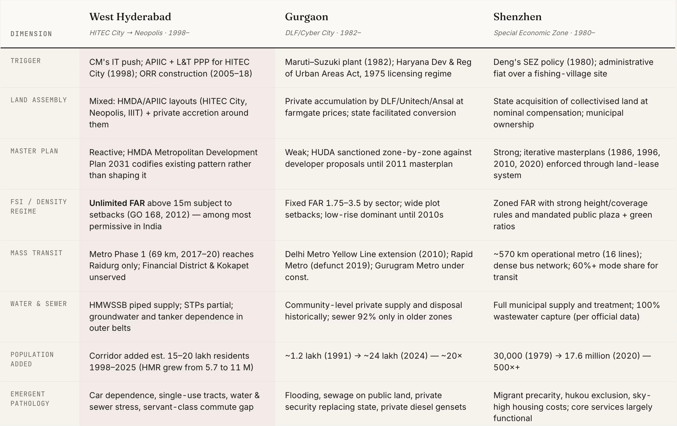
Among the three cities, only Shenzhen retained state agency over the density and transit pattern of what it was building. West Hyderabad and Gurgaon both handed the pattern to developers who, rationally, given their incentives, built gated single-use tracts at the highest FAR they could get. The transit, water and sewer bill is what the state pays afterwards.
The best comparison for west Hyderabad is not Shenzhen (which had state agency), nor Gurgaon (which lacked any state trunk infrastructure). It is a distinct third pattern, created by strong state trunk infrastructure, state land assembly and allocation, weak state land-use and transportation planning, strong private densification, and remarkable entrepreneurship and risk-taking, all riding on a booming IT services industry. This third pattern deserves its own space in the Indian urban development literature.


No comments:
Post a Comment