Substack

Showing posts with label Urban Issues. Show all posts

Monday, August 31, 2026

Some thoughts on the Hyderabad model of urban growth

This is a long read, triggered by a recent article in The Economist lauding Hyderabad’s vertical growth-enabling policy. 

It is an opportunity to think more broadly about the drivers behind Hyderabad’s spectacular urban growth over the last three decades, one with few precedents in India. Also, to avoid drawing the wrong lessons from the city’s success in economic growth and real estate development, this post will provide some qualifications. It will point to the role of the government, the political economy and the role of large developers, and the consequences of deficient urban planning. Finally, it will offer some comparison between the Hyderabad model and those of Gurgaon and Shenzhen.

The Economist article lauds Hyderabad’s vertical growth and the enabling policy of the government. 

Hyderabad, unique among India’s cities, abolished fsi in 2006. And then, miraculously, life went on. NIMBYs foretell all sorts of doom the moment anyone talks about building anything. They warn of Gothamesque ghettos with gridlocked streets, dry taps and overflowing sewers. Nonsense. Today tall residential blocks line the highways in Hyderabad’s western suburbs and traffic still flows faster than in most major Indian cities. Dozens more towers, including the Trump ones, are sprouting in a neighbourhood called Kokapet that was not long ago full of custard-apple orchards and is now a forest of construction cranes. 

There are two reasons Hyderabad has not descended into dystopia. One is its 160 km-long orbital motorway, the first bit of which opened in 2008 and is now an arterial road in the new skyscraper belt. The other is that abolishing the arbitrary cap on FSI did not mean the abandonment of all rules. Regulations covering minimum street widths and required setbacks still apply. Aviation authorities impose restrictions around air-traffic funnels. The effect is that developers can build high only if they have a large enough plot next to a wide enough street somewhere far enough from an airport. Markets decide the rest. The cost of construction rises with height, so a builder’s decision about how much to pay for land and how tall to go rests on whether potential buyers of flats will cough up enough to make the project profitable. That has prevented a housing bubble.

For a start, Hyderabad’s spectacular urbanised growth over the last three decades owes primarily to government actions. Four, in particular, stand out. 

1. The spurt of IT services industries locating to Hyderabad provided the economic anchor to sustain the spectacular property development that followed. Its emergence owes all to government policies. From having nothing apart from a small software cluster at Mythrivanam, the spectacular boom in the IT industry was catalysed by the conscious efforts of the then government of Andhra Pradesh in the mid to late nineties. It established the 158-acre HITEC City at Madhapur through a PPP between APIIC and L&T, with Cyber Towers being the iconic building. The then Chief Minister, Mr Chandrababu Naidu, toured the US and Singapore extensively, wooing software firms, and his efforts culminated in Bill Gates's visit in 2001 and the announcement of Microsoft’s largest R&D centre outside Redmond. It was followed by GE and ICICI and a flood thereafter and continues to this date, expanding to all kinds of sectors and innovations. The Cyberabad brand took off. 

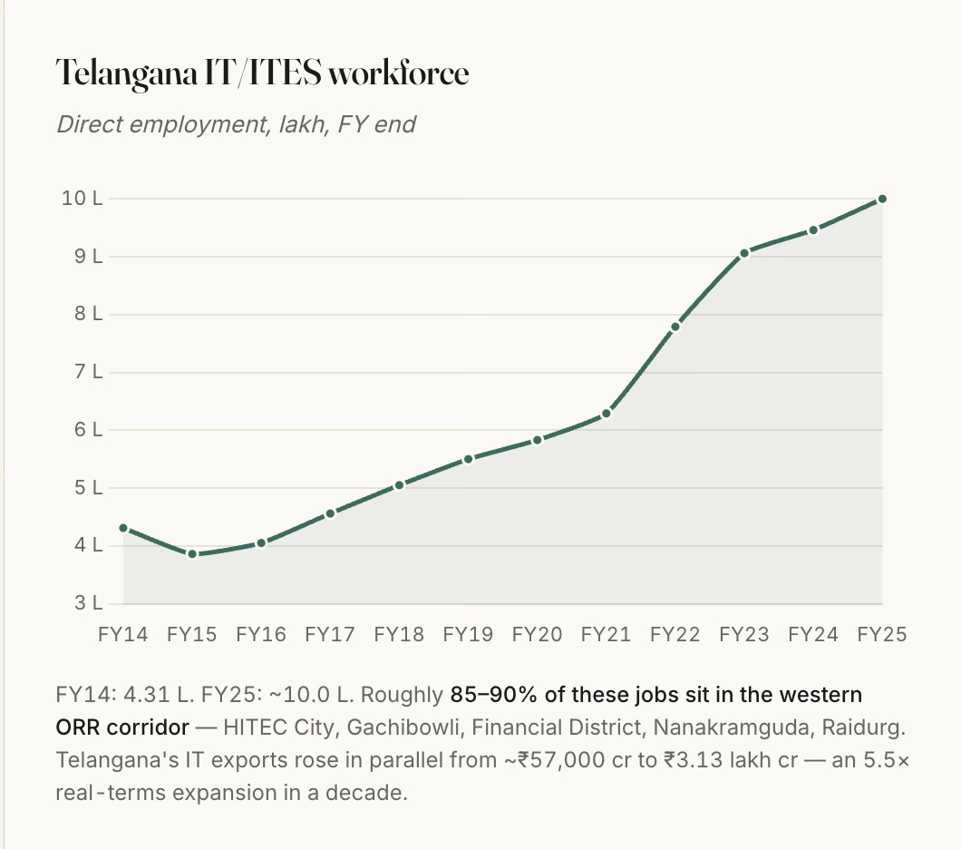
Starting with a few hundred in the early nineties, Telangana state’s IT employment has moved from 0.4 million in FY14 to about a million in FY25, and 85–90% of that sits in the western Hyderabad corridor. 
2. The state’s IT services push was supported by the Andhra Pradesh Infrastructure Investment Corporation (APIIC)’s model of acquiring land, developing trunk infrastructure (transport and utilities), and leasing/selling with clear titles through a single window at concessional rates to incoming firms. This too, like with the ORR, had its set of controversies and scandals.

Apart from the L&T HITEC City, APIIC developed the initial 100-acre Financial District at Nanakramguda, and several others. HMDA has been the price-discovery mechanism for the entire premium belt through its periodic auctions that have unlocked vast extents of government lands. The high premium commanded by these auctions is also because the state layout provides serviced plots with clear title. This is closer to a Chinese SEZ-style state land-lease model than to Gurgaon's private-land-assembly model.

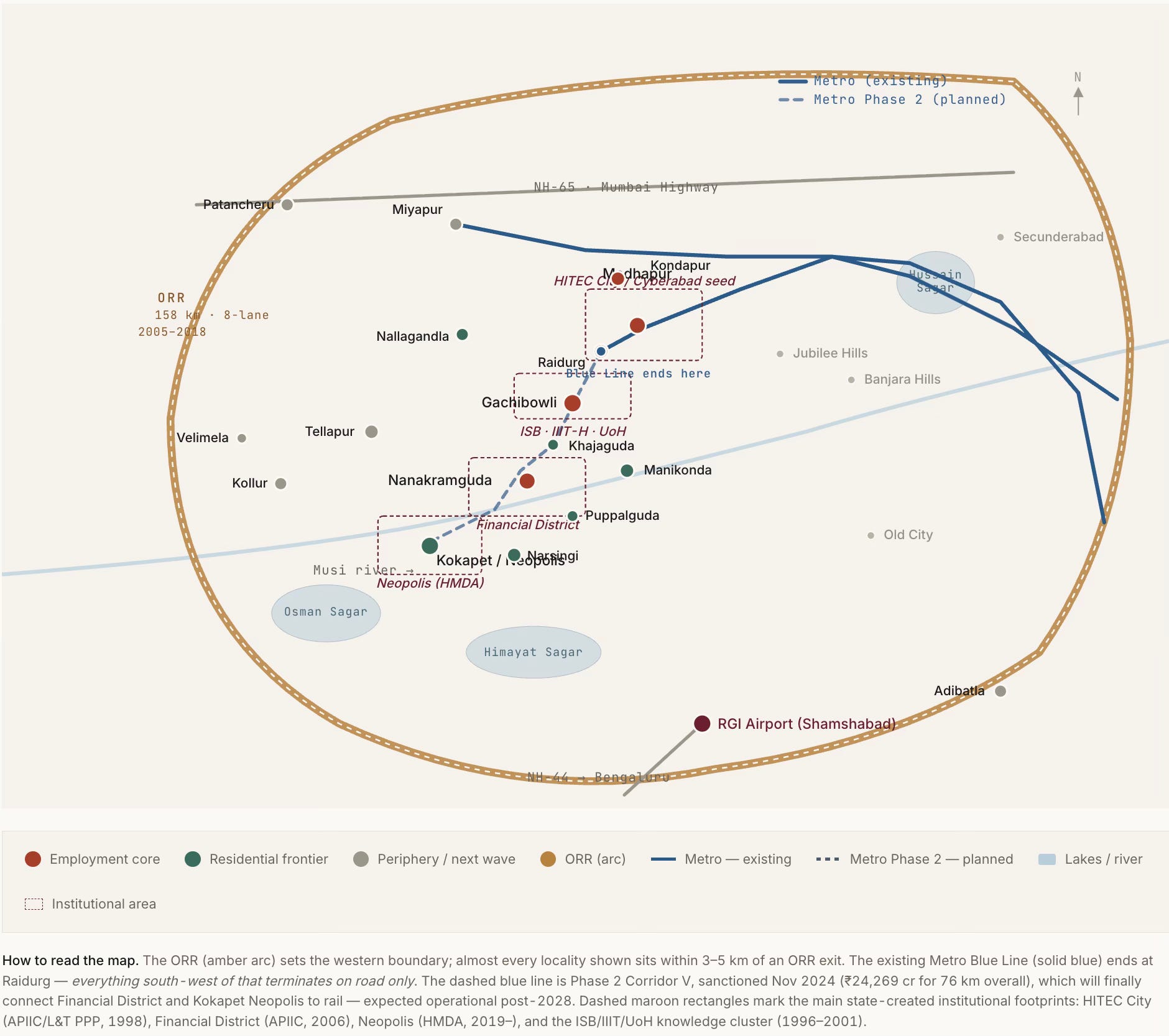
3. The Outer Ring Road (ORR) has been transformational to the urban growth in the western part of the city. Notwithstanding all the controversies on the alignment finalisation, land acquisition, contracts, and tolling, the Hyderabad ORR should count as a totemic example of high growth-catalysing infrastructure investment in India’s history. It unlocked value by enabling the vast hinterland of barren and rocky lands to become productive centres. It was a truly visionary project when conceived in the early 2000s and even when its execution started in 2005. 

The ORR enabled orbital and radial access to the city, thereby resetting the commute dynamics and unlocking vast barren lands, reducing times by multiples. It is no surprise that every land price in the corridor is capitalised against ORR access time. HMDA’s designation of a 1-km high-density buffer on either side of the ORR effectively unlocked about 316 sq km of premium-development-eligible land, the value created from which dwarfs the ₹6,700 cr cost of the road itself.

The ORR did the work of several economic growth crowding-in instruments, and produced the pattern of intense capitalisation of access to it, and (on the flip-side) the neglect of everything it does not touch.
4. The last enabler, the subject of The Economist article, is the deregulated development control regulations, specifically the unlimited FAR adjoining wide roads brought in by the GO Ms No 86 of 2006. In fact, even among the DCR, the GO’s success was only in its deregulation of the FAR. The high FAR manifests in the most salient aspect of Hyderabad’s real estate growth, the skyline of massive high-rises. 

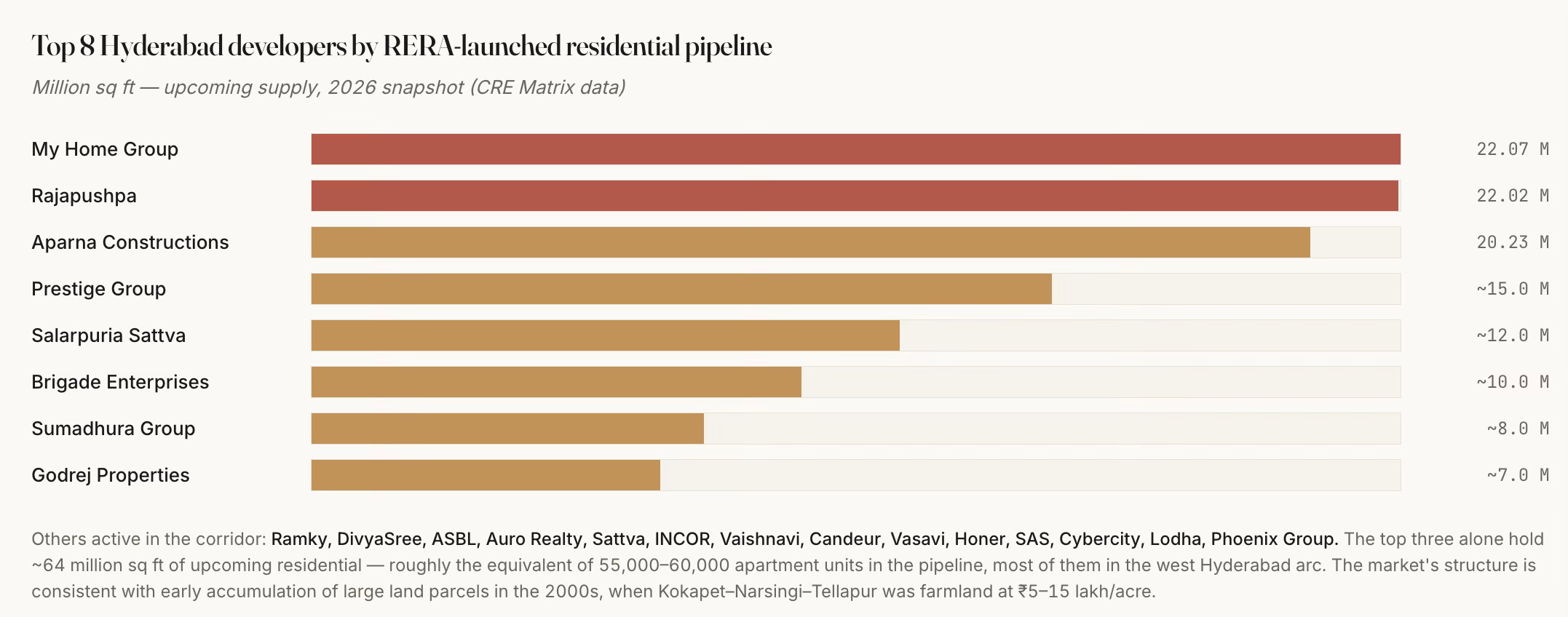
Even with all the above, it also critically required the enterprise, vision, and risk appetite of a handful of local real estate developers (My Home, Rajapushpa, Aparna, etc.) who hoarded large land banks in anticipation of the developments since the late nineties and early 2000s in the run-up to the boom. Only large real estate developers could afford to take the risks that lock up huge upfront capital and endure the vagaries of business cycles. 

However, it has managed to escape the market concentration that characterises markets like Gurgaon. The nature, scale and pace of development have also ensured that while a dozen developers account for the bulk of Grade-A supply, and the top three alone control about 64 million sq ft of upcoming pipeline, there is a long tail of over 30 mid-tier local names.
Such entrepreneurship could also flourish only in a political economy and social milieu which condoned the often questionable overlapping of public and private interest, and deep-rooted corruption. Governments changed, but the underlying model and ongoing work continued unhindered. It is a very good example of Mancur Olson’s stationary bandit at work. 

The combination of the 158-km Outer Ring Road, an unlimited-FSI building regime, a hospitable IT policy, and a handful of developers with 2000s-era land banks has added roughly a mid-sized city's worth of office, housing and vehicles to a 200-square-kilometre arc of west Hyderabad in about a decade-and-a-half. The public sector supplied the foundation. The private sector built on it. What emerged are pockets of car-dependent, single-use, higher-income, gated communities, with limited mass transit or affordable housing. 

This brings us to the issue of urban planning. 

Here, apart from the single instrument of unlimited FAR in the development control regulations, it is notable that the state fell short on the critical aspects of urban planning - master-planned mixed-use, walkable street grids, timely metro and mass transit access, transit-oriented density transfer, affordable housing, and vibrant public spaces and community life (apart from those in the gated communities). Even the unlimited FAR has its set of problems. 

However, it can also be argued that more than state failure, these outcomes were the result of private incentives and the political economy overwhelming urban planning imperatives. The reality of developers with large land banks near the ORR and their close relationships with both politicians and bureaucrats trumped all other factors. 

In any case, they have had several undesirable long-term consequences. Here are a few.

1. Residential real estate development has almost completely taken the form of high-rise gated communities and villas, all serving the upper middle-class and above. Affordability has been the casualty. 
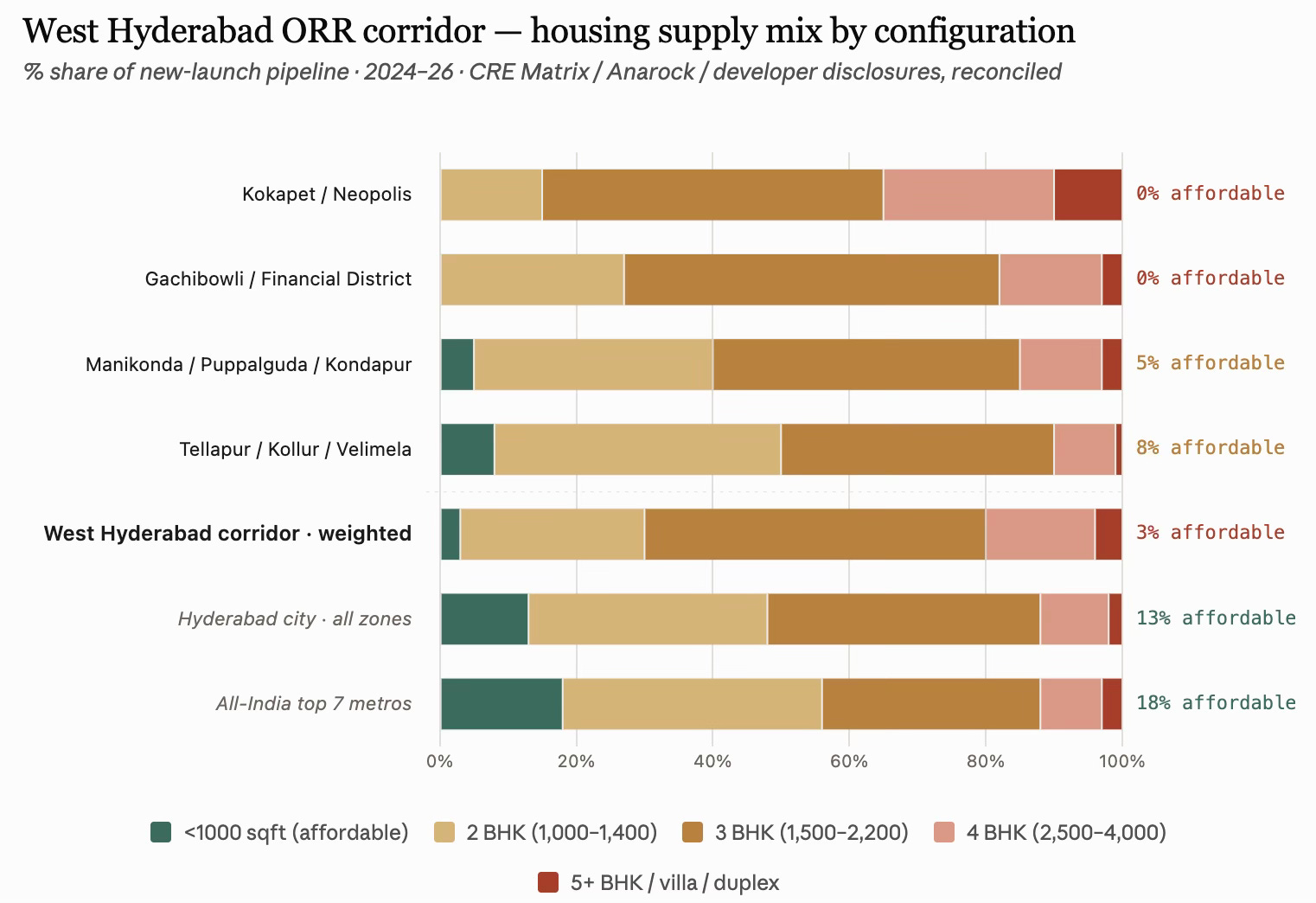
The sub-1000 sqft supply is a mere 2–4% of the west corridor’s pipeline, versus 13% for Hyderabad city and 18% at the all-India top-7-city level. Apart from public housing under various government schemes, it will be a big surprise if there is even one development of housing in the 600 sqft range and below, catering to the lower-income class. The corridor’s default product is a 1,500–2,200 sqft 3 BHK, forming half of everything built, and easily catering to the upper-income class. 

This is a resounding nod to the reality that even in the most deregulated contexts and rapidly growing economic regions, affordable housing and lower-income housing will remain heavily under-supplied. It must be acknowledged as an area of market failure, requiring policy action. 

A ₹10 lakh household income supports roughly a ₹65–80 lakh home, which puts everything from Kokapet, Financial District, Gachibowli, Madhapur, and Raidurg out of reach for a typical mid-career IT professional. Even a ₹25–30 lakh household income (senior IT / GCC AVP) is stretched at ₹2 Cr pricing in Financial District. What this means is that the corridor is now selling primarily to senior tech and finance executives, NRI, and dual-earner-tech/finance households. Junior and mid-level tech workers are being pushed to Tellapur/Kollur/Miyapur. Even in these peripheral areas, sub-1000 sqft housing reaches only about 8%. 

2. The revenue bias of the state government may have compounded the problems. The massive premiums commanded in the land auctions, coupled with the restrictive DCR (on setbacks and open space requirements), have distorted the real estate market and skewed it significantly upwards. For illustration, at ₹150 cr/acre for Neopolis land, the input land cost alone works out to ₹8,000–10,000 per saleable sqft (assuming 2.5–3.5 FSI usable given the large setback and open-space rules). Add construction (₹3,500–5,000/sqft for a premium tower), financing costs (typically 12–18% of project cost), developer margin (20–30%), and GST and other statutory levies/fees, and the total cost comes to ₹13,500–17,000/sqft. This land economics forces ₹4 Cr and above units. In contrast, in Velimela, where land is still ₹5–10 lakh/acre (not for long, one would imagine), 2 BHKs can come at ₹40 lakh. 

In fact, it can be safely said that the entire land-use regime consisting of the ₹150 cr/acre Neopolis land price, the setback rules that make sense only for large plates, the developer economics that require more than ₹80 lakh units to sustain the ORR-belt cost stack, has displaced sub-1000 sqft out of the ORR corridor. The real affordable-format supply in Hyderabad now exists outside the ORR corridor’s western arc, in Miyapur, Bachupally, Nizampet, Kompally (north-west), Kukatpally (central), Uppal, Nagole, LB Nagar, Ghatkesar (east), and Rajendranagar, Shamshabad, Adibatla (south). These are outside the ORR corridor’s western arc. Anarock’s Q3 2025 Hyderabad realty breakdown indicates that 87% of the new supply added was in the premium, luxury, and ultra-luxury segments, priced upward of ₹80 lakh, a figure which rises to more than 95% in the ORR corridor. These are figures that point to a serious housing crisis. 

3. This has been despite the HMDA having a 5% of developable area mandate for each of the Economically Weaker Section (EWS) and Lower Income Group (LIG). Builders have the flexibility to construct it on alternative land within a 5 km radius. However, there is not even a single instance of any developer having built physical units using this option. Instead, they have preferred to use the cash-out loophole of paying a shelter fee, which was carved by amending the Special Development Regulations for the ORR Growth Corridor. It allows developers to pay a capitalisation fee equivalent to 1.5 times the basic land value to HMDA. The low basic land value means this becomes a cheap option, one immediately capitalised into the cost of construction. 

This must count as one of the biggest missed opportunities of Hyderabad’s ORR-based growth, and adds to the list of planning and policy failures. More importantly, the amendments to the EWS/LIG mandate underline the dominance of real estate developer interests. 

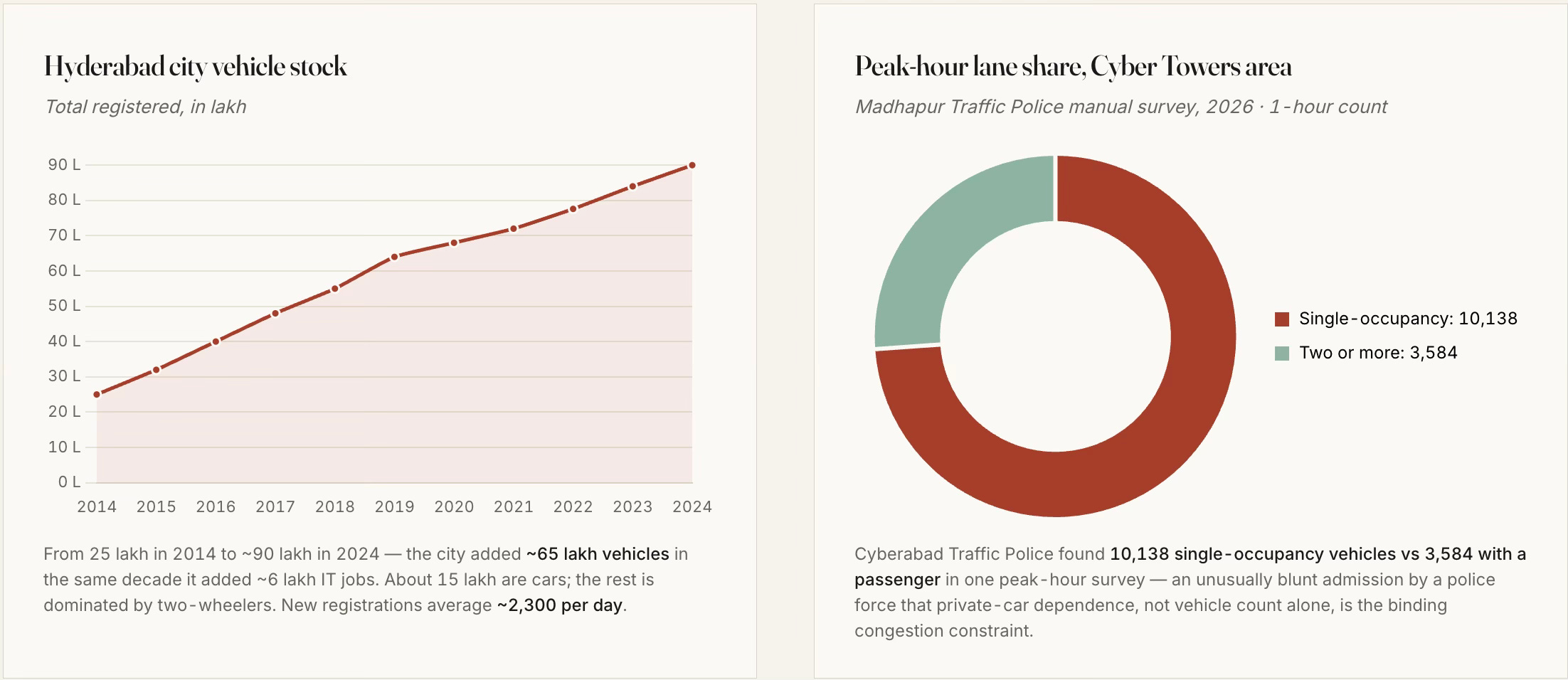
4. Also, given the lack of any public transport connectivity linking them, these gated communities are car communities. The very large enclosed boundaries of these communities mean that they are not walkable localities, thereby further isolating the communities and increasing the reliance on cars.
The Phase 1 Blue Line of the metro terminates at Raidurg, on the eastern edge of HITEC City, whereas the next 5–6 km, as in the schematic, contains the highest concentration of new office and residential capex in the corridor, and it has no rail transit at all (though they are included in the Phase 2 corridor of 11.6 km whose work has just started). They are also served sparsely by a fragmented bus network. Even when completed, the configuration and the nature of the development in the area make it sub-optimally useful. 

The metro gap is perhaps the single most consequential planning failure of the western corridor. Hyderabad, like others in India, are seeking to fit the metro into a built-form, instead of shaping the built-form around a built or planned metro. 

5. Furthermore, they are also not mixed-use developments (the institutions/offices, residences, and commercial areas are distinct), thereby forcing households to commute to buy their groceries and vegetables. To some extent, the basic requirements are met by having small shops inside each gated community selling groceries and vegetables/fruits. But outside of this, all commutes are long and car-based. It is unsurprising, therefore, that, like elsewhere in India, there is not one example of Transit Oriented Development (TOD) among the current stations. 

6. The absence of lower-income housing, coupled with the redevelopment and gentrification of even the erstwhile villages, has meant that West Hyderabad must rely on distant areas for various household services. Housemaids, drivers, and other help must travel long distances using autos and bikes to come and work in these communities. Apart from the costs on their lives, this creates their own set of problems (like getting a housemaid early morning or having a driver stay back late, or even their reliability). 

7. The “unlimited” FAR also meant that the government has foregone large revenues in the form of sale of purchasable FAR permitted over a base FAR (which comes with the property right). It can, however, be said that its absence has lowered the cost of construction and boosted supply. For now, the foregone revenues have been recovered many times over in various forms of economic activities, thanks to all the complementary actions that confluenced in the region’s development. 

All this means that West Hyderabad has made its choice of a pattern of living that revolves around secluded gated residential communities and is car-based, instead of the walkable, mixed-use, mass-transit and outdoor public-spaces-based living that characterises many western cities. There are benefits and costs with each model. But once the choice is made, it is almost cast in stone. 

It is also pertinent that while West Hyderabad has developed at this pace, the same planning and development control regulations (DCRs) have had no impact on the rest of the city. Economic growth over the last two decades has largely bypassed the existing twin cities of Hyderabad-Secunderabad and facilitated western suburban expansion. It is hard to think of even one example of meaningful-sized urban regeneration or redevelopment in the remaining parts of the city. It can even be argued that the development of the western ORR corridor has come at the cost of the rest of the city. 

This also reflects the restrictive nature of the existing DCRs, despite the unlimited FSI. Very few, or hardly any, plots in the built-up city can avail this unlimited FSI, thereby pushing development outside to the suburbs and benefiting builders. This is one more illustration of the fact I blogged here that reforms to DCRs across Indian states have largely bypassed the built-up city and benefit only the greenfield suburban developments. 

How does Hyderabad’s development compare with two similar examples of rapid growth to scale - Gurgaon and Shenzhen? 

Unlike Gurgaon, which emerged primarily on the back of private land assembly enabled by the licensing regime of Haryana’s Development & Regulation of Urban Areas Act (1975) and even private infrastructure development (e.g., CyberHub metro), the government had a big role to play in the development of the other two. In Hyderabad, as aforesaid, the government aggregated lands, allocated and auctioned them, while also developing the trunk infrastructure. 

Shenzhen is the extreme case of transformation of farmlands, with population rising from a mere 30,000 to 17.6 million in 40 years, and is instructive for its sequencing. It built the metro alongside, not decades behind, the office and housing pattern. Shanghai Pudong transformed farmland east of the Huangpu into finance-and-office from 1990 onward, but again with subway preceding the office boom. Songdo (Incheon) in South Korea is a smaller-scale but similarly planned-from-blank comparison.
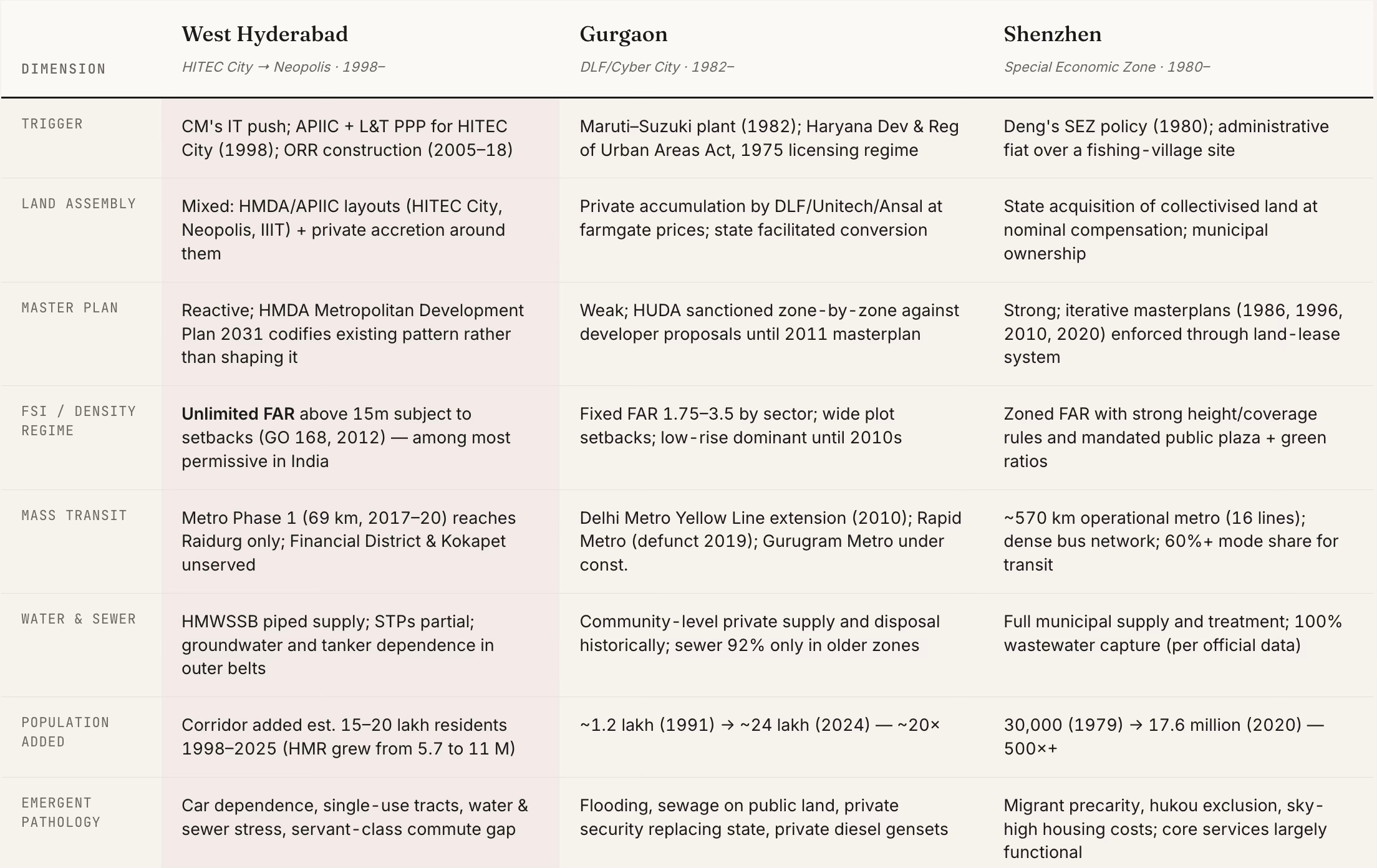
Among the three cities, only Shenzhen retained state agency over the density and transit pattern of what it was building. West Hyderabad and Gurgaon both handed the pattern to developers who, rationally, given their incentives, built gated single-use tracts at the highest FAR they could get. The transit, water and sewer bill is what the state pays afterwards.

The best comparison for west Hyderabad is not Shenzhen (which had state agency), nor Gurgaon (which lacked any state trunk infrastructure). It is a distinct third pattern, created by strong state trunk infrastructure, state land assembly and allocation, weak state land-use and transportation planning, strong private densification, and remarkable entrepreneurship and risk-taking, all riding on a booming IT services industry. This third pattern deserves its own space in the Indian urban development literature.

Monday, August 24, 2026

Derisking the financing of infrastructure sector segments

A striking feature of urban infrastructure financing in India is the negligible role played by debt, especially bank loans. It should be a policy priority to significantly increase the mobilisation of debt prudently and sustainably for urban infrastructure projects. 

In this context, I have blogged here with a proposal to leverage the viability gap funding (VGF) scheme of the Department of Economic Affairs, Government of India, to mobilise bank loans and other debt. The idea is to use VGF to transform the project economics to make it commercially viable for banks to lend to municipalities without a sovereign guarantee and against project revenues. This would be an incentive-compatible form of desirable debt, and also provide a pathway to boost the uptake of the struggling VGF window. 

The newly announced Urban Challenge Fund (UCF) of the Government of India is a step in this direction. The ₹1 lakh crore scheme seeks to transition cities toward market-based financing by providing central assistance up to 25% of the total project cost for projects that are able to mobilise at least 50% of the project cost from market sources like commercial bank loans or municipal bonds. The remaining 25% is to come from state and municipal governments. 

The UCF should avoid the kind of incentive-misaligned recourse debt mobilised against the municipal general funds and/or with state government guarantees. Instead, it should try to ensure that the debt is non-recourse, mobilised against project revenues and without any sovereign guarantee. This kind of debt ensures fiscal discipline and a sustainable pathway to financing urban infrastructure. The UCF guidelines are silent on this important distinction. In fact, there is a case for a substantial incentive within the scheme itself to nudge cities in this direction.

However, initiatives like the UCF and VGF are unlikely to generate adequate uptake if they are implemented as a regular government scheme, and directly between the central and state governments. For one, the rigid and bureaucratic nature of project appraisals, approvals, program administration, and payment tranche releases is unsuited to finance projects involving private capital. Further, the operationalisation of such financing will require getting a few things right on both the demand and supply sides, which requires a market-making role. 

On the demand side, it requires the creation of a shelf of projects that can be structured to access project finance. Developing a good quality pipeline of ready-to-finance projects entails a non-trivial cost and requires a project development fund. The category of projects, like those in water and sewerage, solid waste management, bus transit, electricity distribution, etc., are best placed to benefit. 

On the supply side, it requires derisking and increasing banks' appetite, in particular, to finance such projects. Nothing is more effective than a few successful demonstrations of project finance for municipal projects. Today’s commercially attractive infrastructure sectors like national highways, thermal and renewable power generation, parking, etc., got derisked over time through a handful of successes.

This facilitation of the demand-side and easing of supply-side concerns requires active market-making. The infrastructure development finance institutions (DFIs) like National Infrastructure and Investment Fund (NIIF) and National Bank for Financing Infrastructure and Development (NaBFID) are well placed to act as infrastructure investment banks to make this happen by providing technical assistance to develop the project and structure project financing (without recourse to general municipal funds or state government guarantees), mobilising lenders to help achieve financial closure, and contributing the derisking financing layer. 

Accordingly, at least a part of the grant allocation for schemes like VGF and UCF could be made available for these DFIs to build a pipeline of projects and finance them. A proportionate share of the Project Preparation and Capacity Building Fund (PPCBF) under the UCF should also be transferred to them. This should be part of an explicit mandate for these DFIs to derisk projects clearly specified sectors for bank and bond finance. 

If successful, it would be a powerful example of market catalysis of the kind that is central to the mandate of DFIs.

Tuesday, July 21, 2026

Lessons from Spain for urban planning

Football is not the only area where we can learn from Spain. Energy transition, infrastructure construction and urban planning are some others. This one is about urban planning. 

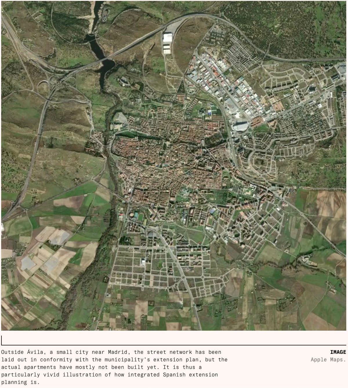
An essay in Works in Progress examined how traditional apartments have declined across Europe, except in Spain, and the role played by late development and public policy. It also underlines how Spain uniquely got all the basics of urban planning right - land readjustment, infrastructure development, mixed-use, densification, connected street network, walkability, mass transit, and low car usage. 

This is a good description of mixed-use density in Spanish cities that promote walkability and mass transit commutes, and limit sprawl and carbon emissions. 

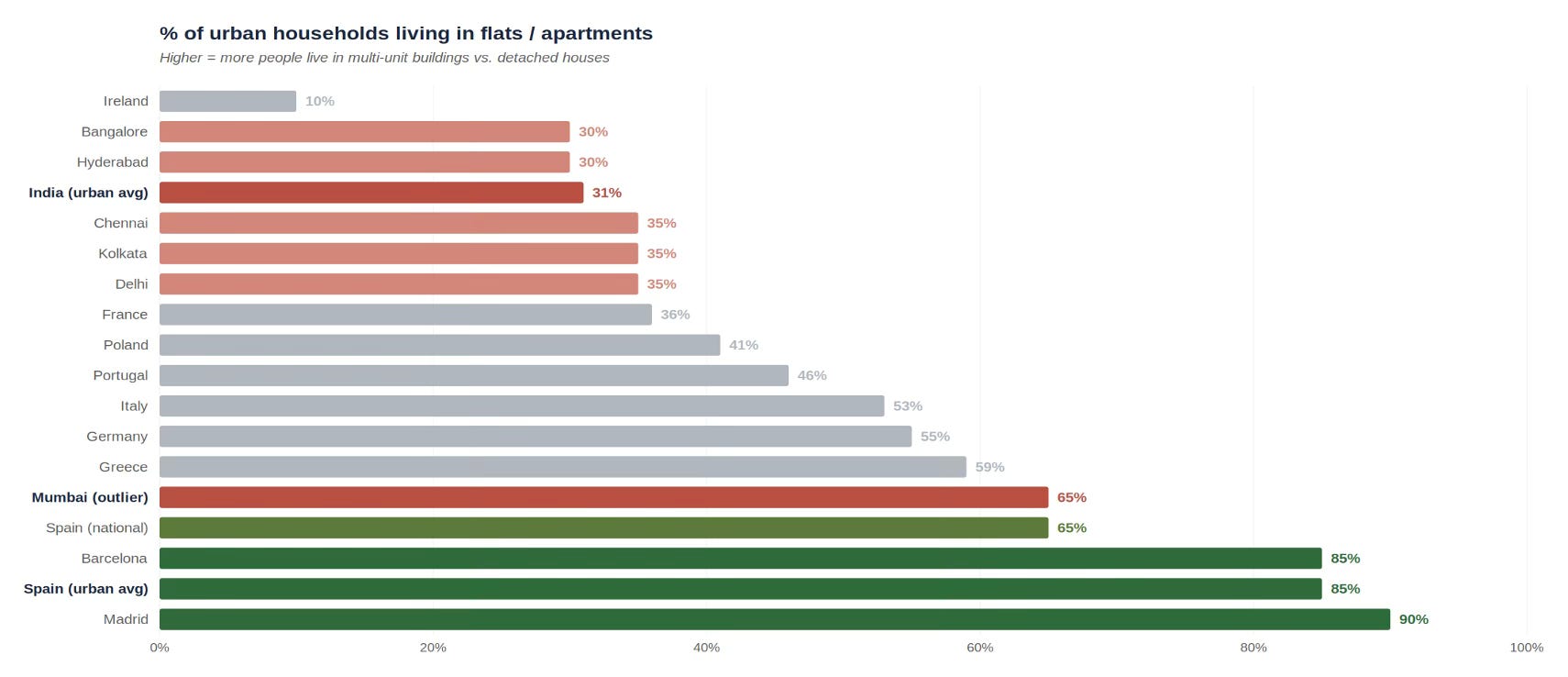
Spain’s cities are unusual. They are much denser, tighter, and more deliberate than other European cities, let alone North American ones. They reject picket fence for apartment block and choose balcony over front lawn. Two thirds of Spaniards live in flats, against 41 percent of Poles, 36 percent of the French, and just 10 percent of the Irish. Of the remaining third, most live in terraced rowhouses. In Spain’s cities, over four fifths of people live in an apartment. At the edge of Madrid or Valencia, dense mid-rise blocks stand beside open countryside without sprawl in between, something that has almost never happened in an English-speaking country, and that has been rare in France or Germany for a century… Spain’s settlements have some of Europe’s lowest per capita transport emissions, in part because about 70 percent of trips in Madrid and Barcelona are made on foot, tram, or metro. Almost every neighborhood is mixed use; almost all urban Spaniards live in the ‘fifteen-minute cities’ that seem like remote ideals in most affluent societies.

This is a good comparison with other Southern European cities, and even here, Spain stands out. 

Spain is not alone in Europe in having become wealthy only recently: most Southern European countries have a similar economic history. And Portugal, Italy, and Greece do share the distinctive features of Spanish urbanism to some extent, with relatively dense cities and relatively high shares of people living in apartments (46 percent in Portugal, 53 percent in Italy and 59 percent in Greece compared to 65 percent in Spain). In other ways, however, Spain is distinctive in Southern Europe. The cities of Portugal, Greece, and Southern or Central Italy are generally surrounded by ragged fringes of unplanned suburban development: their urban cores are dense in the same way as Spain’s, but their peripheries are a chaotic mixture. The transport situation is also dramatically different. About half of journeys in Lisbon and Athens are by car; in Rome, the figure is two thirds, with another substantial share on mopeds; in Nicosia, it is 85 percent, the highest of any European capital. In Madrid, the modal share of cars is below 30 percent. Cities tend to be dense all over Southern Europe, but they have not all achieved the transport outcomes that urbanists associate with density: in this respect, Spain is the outstanding model.

Public policy has played an important role in making this difference. In Britain and the US, the government develops the main arterial roads and allows development that follows the development control regulations, which results in fragmented urban forms (in terms of plot sizes and types of development). In Spain, the authorities undertake land re-adjustments like the Town Planning Schemes of Gujarat and thereby lay down clear boundaries and forms of development. 

This also means a high level of infrastructure development with a high density of roads, based on plans that connect streets and localities to promote pedestrians and cyclists.

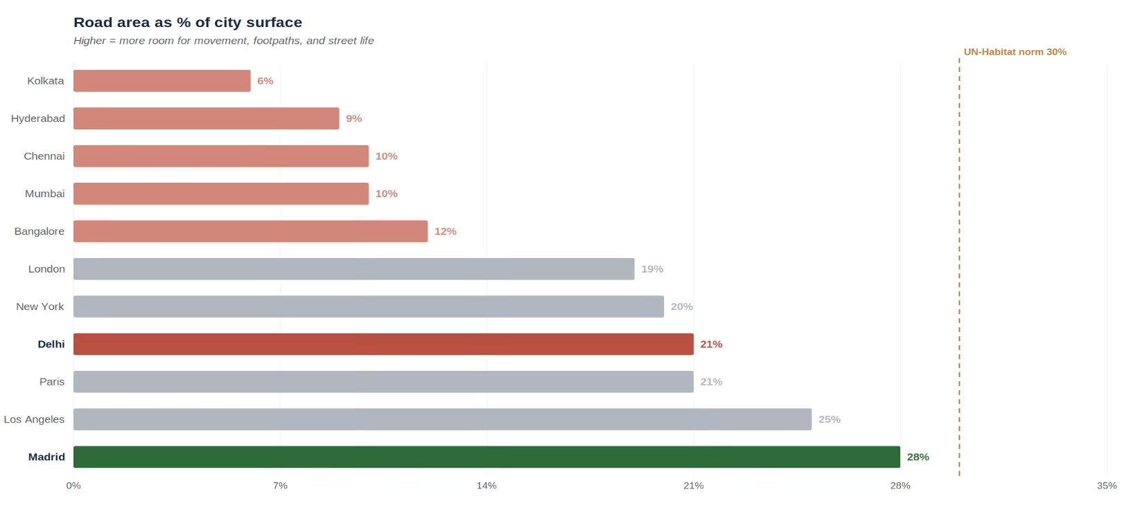
This has yielded cities with exceptionally good infrastructure. About 28 percent of Madrid’s surface area is taken up by roads, almost exactly the 30 percent recommended by UN specialists. This compares to 21 percent in Paris, 19 percent in London and 20 percent in New York. Even Los Angeles, a famously road-heavy city, uses only 25 percent for roads. As we have seen, these roads are also more skilfully interconnected, which is indispensable for pedestrians and cyclists

A large road network has not detracted from policy focus on public transport. 

Despite having far superior road infrastructure, Spanish cities also have high public transport use. Around 60 percent of trips in the Madrid metropolitan area and over 70 percent of trips in the Barcelona metropolitan area are made through public or active travel, similar to other major European cities and far higher than American, Canadian, or Australian cities, which typically fall below 30 percent. In other words, Spanish cities have Los Angeles-tier road infrastructure and Paris-tier public transport access. This is paired with some of the continent’s best intercity transport. Spain has significantly more motorways than any other European country: 17,228 kilometers, versus 13,183 in Germany and 11,671 in France. It has the second-longest high-speed rail network in the world, after China.

In fact, public policy played perhaps an even more important role by keeping infrastructure construction costs low and ensuring construction was done within budget and without delays. It was able to utilise something like €200 billion in cohesion funding received from the EU between the late 1980s and 2020. 

More importantly, Spain kept costs low… Spain, combined with its non-EU injections, built 4,000 kilometers of high-speed rail, 10,000 kilometers of motorway, and numerous metros, trams, ring roads, and radial arterials, because it kept costs extremely low. It did this by maintaining good practice: flexible environmental rules (although these have since become more problematic), top-tier in-house capacity in engineering and contracting, a commitment to a steady pipeline of projects over decades, and, above all, rapid decision-making, avoiding the costly delays and redesigns common elsewhere. Another part of this was giving small areas the power to decide on and fund infrastructure, like the Madrid Metro, avoiding the ping pong between authorities seen in some high-cost countries. 

Together, this has allowed it to build metros more than 20 times cheaper than in New York City. For the price of one mile of the New York’s Second Avenue Subway extension, Spanish builders covered the entire 35-mile 1995–1999 expansion of the Madrid Metro. As a result, Spanish transport infrastructure is both abundant and cheap. Madrid’s metro underwent one of the fastest growth spurts in the worldbetween 1995 and 2007, adding around 203 kilometers of new lines to its already impressive footprint​. Barcelona has been continuously expanding its metro network since the Second World War: in a period of astonishing activity between 1990 and 2010 there were 18 separate extensions, and seven more since.

Cities including Valencia, Bilbao, Seville, and Málaga all built metro or light rail systems in the 1990s and 2000s. Madrid and Barcelona have both joined their old suburban rail lines up into Cercanías/Rodalies systems, similar to London’s Crossrail scheme but far more comprehensive (though not always well run). The upshot of this is that, despite having some of the world’s best road infrastructure, Spain still has relatively low levels of car use and ownership: the modal share of driving is low not because driving is a bad option, but because other options are so good.

Since the late 2000s, changes in laws placing a series of restrictions on buildings have adversely impacted Spanish urban planning. For example, before 2007, Spanish land was buildable by default; the same was inverted to allow housing construction only if specifically zoned by the local council. Today, in an emulation of the planning practices followed in the US and Europe, building in Spain has become extremely restrictive. 

Planning a major Spanish urban extension now depends on agreement from the municipality, the community (the regional government), the landowners, and, individually, each of the environmental, water, roads, electricity, public transportation, and social housing authorities. The result is that creating new city plans now takes an enormously long time. Creating the plan takes between six to eight years, while designing the streets and plots takes another three to seven… This is leading to high prices. Madrid asking prices are now nearly €6,000 per square meter, and Barcelona over €5,000, above Hamburg, Berlin, Frankfurt, Brussels, Milan, and Rome… But Spanish wages are low… This has left leading Spanish cities with some of the worst house price to income ratios in Europe.

Spain offers important lessons for cities in developing countries like India. Spain’s late development means that its experience has even greater relevance for us. 

Spain's cities are unusual not on any single dimension but on the combination - density, mixed use, mid-rise (not high-rise) apartments, walkability, cheap and abundant transit, high car ownership but low car use, infrastructure preceding development, and municipally planned street grids. Spain is unique in getting all the dimensions right. 

Indian cities, from metros to the lower-tier ones, are characterised by a far lower share of multi-tenement units, rigid land-use restrictions, high setbacks, poorly maintained or absent footpaths, infrastructure coming well after habitations emerge, and sorely deficient mass transit facilities (especially bus networks). 

In India, exclusive land-use zoning is the norm, with mixed-use permitted only beyond generally 15-18 m roads and above, which are present in a very small proportion of the localities. In the older areas, commercial facilities in residential areas have emerged informally over time, whereas in the planned colonies and new developments, mixed use is restricted. 

Indian cities have among the lowest share of urban households living in multi-tenement units, with Spanish cities being at the other extreme. Only 31% of urban Indian households live in flats (NSS 2018) compared to about 80% in Spanish cities, with Mumbai being the exception. The India NSS “flat” includes chawls, single-storey shared tenements, and informal walk-ups - so Indian numbers overstate what a Spaniard would recognise as a flat.

Similarly, Indian cities have among the lowest share of road network, not even a third of the UN Habitat norm. Most Indian metros are 6–12%, with only Delhi, the only Indian city with municipally planned extension, getting close.

I can think of at least a few big takeaways. Foremost, there’s no alternative to mixed-use, densified development for both greenfield and brownfield areas. 

Given its high share of detached housing, Indian cities have a great opportunity to reinvent themselves. This can be done by increasing FAR, and more importantly, doing it in a manner that allows upzoning adjacent to 9 m and 12 m roads. As I blogged here, the current upzoning deregulation, confined to plots with road width greater than 18 m, is largely superfluous. 

This must be coupled with planning norms like allowing for relaxations of setbacks, even dispensing with them and encouraging row housing, multi-tenement units, and mixed-use in terms of encouraging commercial amenities. The latter is about ensuring that people living in a locality should be able to buy their regular groceries and other household items and services from within there. Further, the local government fee and property tax regimes must consider lowering the layout development charges, building permission fees, and property taxes to encourage the realisation of these objectives. 

These policies and instruments must be deployed with a long-term perspective (as against expectations of immediate results). The objective should be that they would shape incentives and enable the gradual redevelopment of brownfield areas as densified communities. 

Second, we must use urban planning to lay down street network configurations that enable connectivity and walkability. Master plans and their development plans should keep this in mind. Minimising or even eliminating setbacks would be one step to enable such street networks. The prioritisation of walkability requires the infrastructure of footpaths and street connectivity to be able to walk, and the supply in terms of mixed-use amenities to create the demand. And all this must be combined with local campaigns to promote the culture of keeping footpaths free of encroachments. 

Third, the current dominant trend across Indian cities of the emergence of gated communities in the suburbs must be examined. These communities, while attractive for their residents and developers, go against all principles of sustainable urban development. These are largely monocultures of upper-middle and higher-income housing (the maids and drivers, and others, commute from distant places), with exclusive residential zoning, limited or no mass transit connectivity, exclusively car-based, and very poor external street connectivity (large gated enclaves with one or two entry/exit points). They impose massive negative externalities on the city and locality, while appropriating all the benefits. 

Fourth, mass transit must be at the core of all developments. All greenfield areas, in particular, must be planned around mass transit, in the form of transit-oriented development (TOD). This post discusses some principles for TOD in Indian cities, and this post outlines some of the challenges. This would require going beyond the current norm of merely giving higher FAR and offering significant incentives on fees and taxes to make it more attractive for developers to build inside the TOD zones. 

Like in Spain, the challenge is to get the combination more or less right. The good thing is that all of them lie with the states and mostly with the cities themselves. It is only required for 2-3 cities to take the lead and strike out on their own in following these principles and reinventing themselves. They can be the lighthouses that guide urban development in India. 

Wednesday, July 15, 2026

Higher FARs, but very few plots can avail them

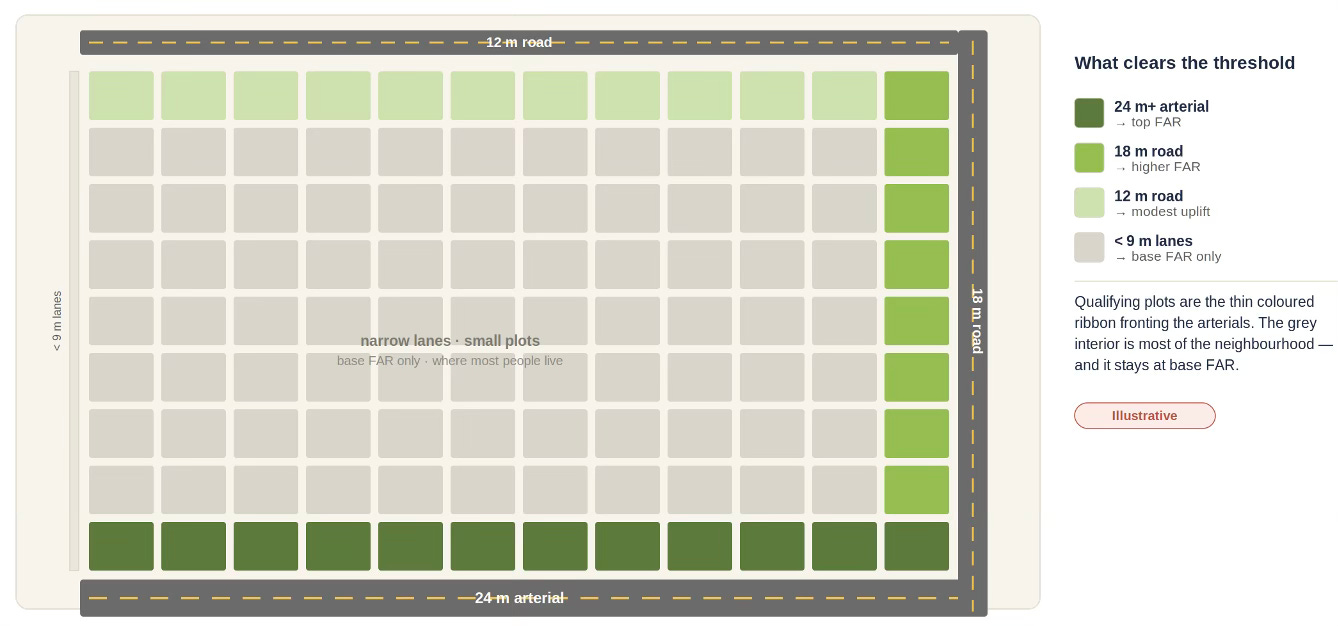
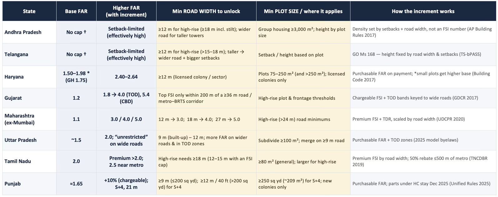
Many state governments in India have issued executive directions increasing the permissible Floor Area Ratios (FARs) in their cities. However, these upzoning reforms are likely to struggle to meet the objective of densification due to restrictive conditions to avail the increased FAR. Specifically, three gate-keeping elements - minimums on road width and plot size, and a maximum on height - leave the upzoning reforms largely stillborn. 

To understand why, we need to keep in mind the street layout of the typical Indian city. The colony street widths are typically 9 m (30 ft) or less, and at best 12 m (40 ft). Even the connecting roads are no more than 12 m. In any city, a very small proportion of properties, and an even smaller proportion of residential land use, will have road widths greater than 9 m. Only the arterial roads, which are in any case mostly commercial and higher-valued, are above 12 m.

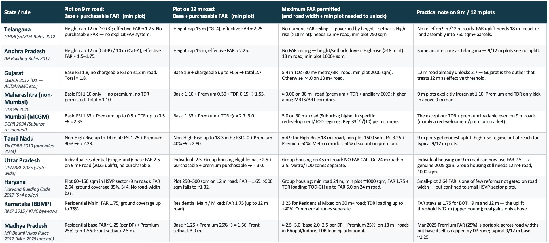
A comparison of upzoning reforms across the ten biggest states reveals some interesting insights. For a start, the upzoning itself is generally marginal, and even where significant, the higher FARs can be realised only on wider roads. In simple terms, the upzoned FAR apply to a tiny minority of parcels - greenfield layouts and edge plots on arterial roads. Every state except Gujarat, UP (individual) and Haryana (small plot) sets the FAR uplift threshold above 12 m - typically 18 m, 24 m or 30 m. But even for the three, the uplift is marginal and only for a few categories of properties. Also, none of the three touches group housing or vertical redevelopment on narrow-road plots.

Further, plot size and setbacks compound the problem of a minimum road-width gate. Even where a 12 m road technically qualifies, high-rise / group-housing rules require minimum plot sizes of 750–2000 sqm and setbacks of 6–12 m. In existing settlements, individual plots average 60–150 sqm, and assembling five to twenty of them is legally and commercially nearly impossible without a TDR/land-pooling instrument. Even then, practical challenges are daunting.

This also means that even the TOD zones cannot benefit from the upzoning. In existing town cores, which are where TOD catchments actually sit, FAR reform delivers almost nothing until the road-width and plot-size gates are lifted or bypassed. 

In other words, the upzoning reforms largely bypass the built-up city and are relevant only to the greenfield areas. In these areas, the uplifts linked to higher road widths end up benefiting only the large developers. They, in turn, build high-rise gated communities of higher-end housing, mostly unconnected to mass transit and with multiple car-users in each household. Ironically, this also ends up expanding the sprawl, flooding the roads with cars, thereby worsening traffic and increasing pollution.

On the other hand, it does nothing for the smaller developers who are likely to develop affordable mid-rises (say, 6-12 floors) inside the existing colonies. Instead, they end up constructing low-rises (up to 4-5 floors). Further, the unit economics given high land prices mean that even these low-rises gravitate towards the suburbs. 

It is these mid-rises that are likely to contribute meaningfully to expanding supply and addressing the affordable housing problem. Unless the upzoning covers the 9 m road width and smaller plots (which make up the vast majority of the potential developable properties in any city), there cannot be any significant impact on housing supply and the affordable housing problem. 

Further, to realise the full potential of such upzoning, it must be complemented with sharply increased mass transit services, especially buses, that cover these colonies. The quality, frequency, and connectivity of the bus network must be high enough to induce people to shift from car usage.